Story
Flood Watch Continues For Salina Area After 1.78" Of Rain The Past 2 Days
October 1, 2026
weather, forecast
Showers and storms will increase in coverage over central Kansas this afternoon and will slowly shift south. Heavy rain and localized flooding will remain the main threat. In addition, a few of the stronger storms may produce some small hail.
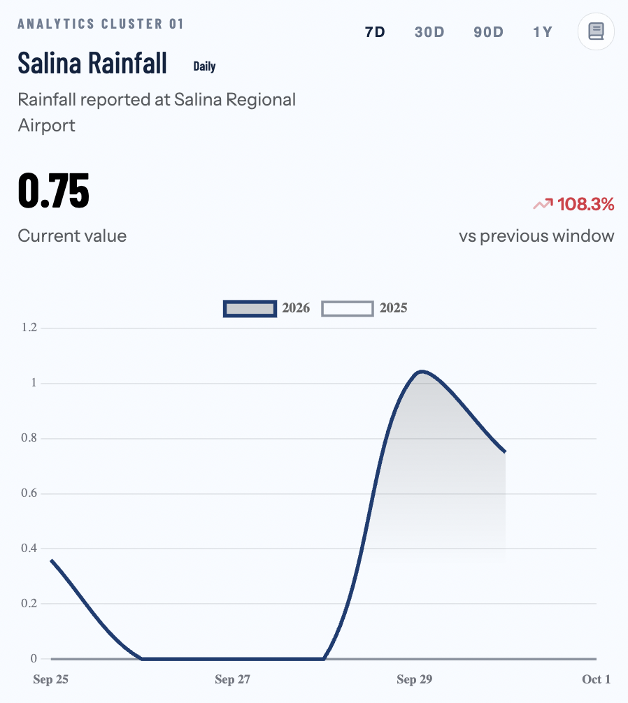
Salina has seen much-needed rain the past two days, with 1.03" of rain on Tuesday and another 0.75" of rain Wednesday.
⚠️ Active Weather Alerts
- 🟠 Flood Watch: Flood Watch issued October 1 at 2:53AM until October 1 at 7:00PM by NWS Wichita KS
- * WHAT...Flooding caused by excessive rainfall continues to be possible. * WHERE...A portion of central Kansas, including the following counties, Barton, Ellsworth, Lincoln, Russell and Saline. * WHEN...Through this evening. * IMPACTS...Excessive runoff may result in flooding of rivers, creeks, streams, and other low-lying and flood-prone locations. Creeks and streams may rise
What Matters Most This Week
- Warmest day: Wednesday, with a high near 81°F.
- Coolest morning: Friday, with a low near 46°F.
- Rain chances: NWS indicates the best chances on Today.
- Storm watch: Thunderstorm chances appear in the forecast on Today.
- Windiest stretch: Today, with gusts up to 44 mph.
7-Day Forecast
| Day | Conditions | High / Low | Rain | Peak Gust |
|---|---|---|---|---|
| Today 10/1 | Chance Showers And Thunderstorms then Showers And Thunderstorms | 72° / 51° | 85% | 44 mph |
| Friday 10/2 | Sunny | 67° / 46° | 2% | 29 mph |
| Saturday 10/3 | Sunny | 72° / 53° | 0% | 11 mph |
| Sunday 10/4 | Sunny | 74° / 52° | 1% | 17 mph |
| Monday 10/5 | Sunny | 73° / 56° | 0% | 27 mph |
| Tuesday 10/6 | Sunny | 79° / 60° | 4% | 31 mph |
| Wednesday 10/7 | Sunny | 81° / — | 6% | 31 mph |
Today's Details — Thursday, October 1
- Conditions: Chance Showers And Thunderstorms then Showers And Thunderstorms
- High / Low: 72°F / 51°F
- Wind: NNE 21 mph, gusts to 44 mph
- Precipitation: 85% chance (National Weather Service forecast)
- UV Index: 1.95 — Low
- Sunrise / Sunset: 07:26 / 19:12
- Daylight: 11.8 hours (0.4 hours of sunshine expected)
What Matters Most Today
- Wind impact: gusts up to 44 mph.
- Best outdoor window: Evening (lowest average rain risk).
Comfort & Conditions
- Humidity: 95%
- Dew Point: Up to 71°F — oppressive humidity
Hour-by-Hour Breakdown
- Morning (6AM–Noon): Overcast, 72°F, 94% humidity
- Afternoon (Noon–6PM): Rain, 68°F, 94% humidity
- Evening (6PM–Midnight): Overcast, 62°F, 88% humidity
Air Quality & Allergens
- Air Quality Index: 30 (peak 30) — Good
- PM2.5: 2.4 µg/m³
Temperatures, conditions, and precipitation chances use National Weather Service forecast guidance. Open-Meteo supplies supplemental wind, UV, humidity, and air-quality fields; its precipitation totals are not used. For weather alerts, visit your local National Weather Service office.
Share this story