75 Years Later: The 1951 Flood That Rewrote Salina's Map
Seventy-five years ago this week, the Smoky Hill River came over its banks and put much of Salina under water. The response to that flood reshaped the city's geography for the next six decades — and the project now underway downtown is, in part, an effort to undo it.
What happened
Between July 9 and July 13, 1951, 8 to 16 inches of rain fell across the region. Kansas rivers rose to levels not seen since the floods of 1903 and 1844. In Salina, heavy rain downstream of Kanopolis Dam pushed the Smoky Hill River out of its channel and into the city.
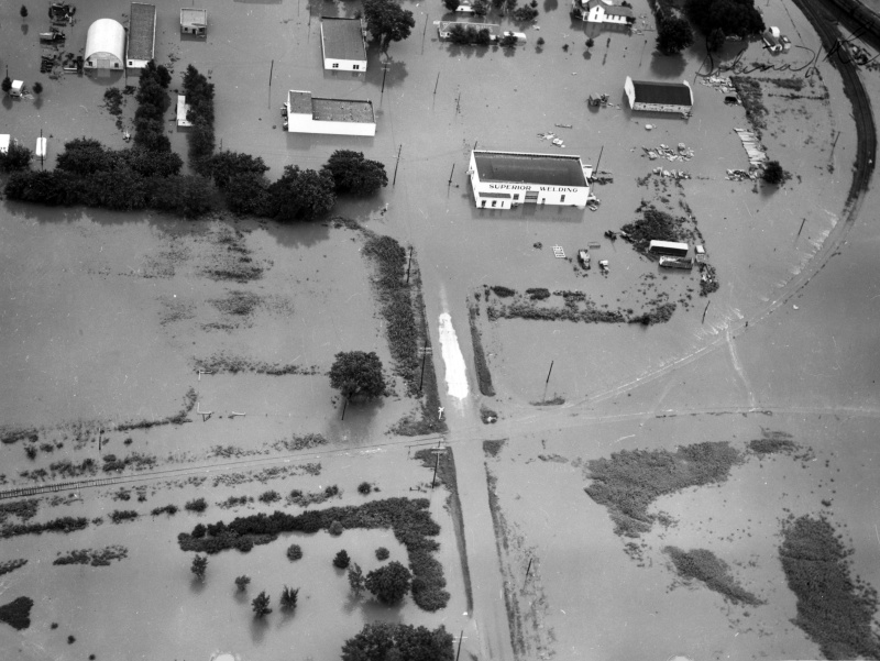
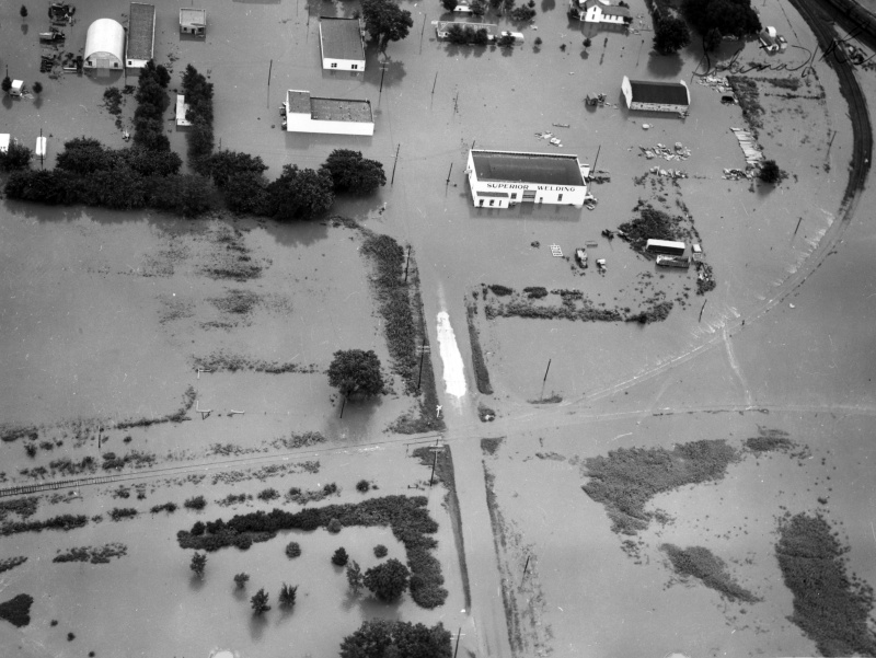
Aerial photographs held by the Harry S. Truman Presidential Library show Salina's business district and residential neighborhoods submerged. Published accounts of the flood report roughly 18,000 people in Salina displaced and community losses of about $3.2 million in 1951 dollars.
Across eastern Kansas and Missouri, the flood killed 17 people, displaced 518,000, and caused more than $935 million in damage — the equivalent of roughly $11.6 billion today.
What Salina built afterward
The 1951 flood is the reason the Smoky Hill River does not run through downtown Salina today.
In 1961, the City of Salina and the U.S. Army Corps of Engineers completed a flood protection project that dug a cutoff channel to divert the river around the city and built several miles of levee. It worked. It has protected Salina from a repeat of 1951 for more than sixty years.
It also cut off roughly 6.8 miles of the river's natural course through the middle of town. That stretch — now called the Old Channel — has been dry or stagnant ever since, filling in with sediment as its wetland habitat disappeared.
What's happening now
Salina is in the middle of a multi-decade effort to bring water back to the Old Channel.
In 2022, Salina voters approved a citywide sales tax for downtown and riverfront improvements. In July 2024, then-Mayor Bill Longbine and Army Corps Col. Travis Rayfield signed a cost-share agreement, the first formal step toward restoring flow. City documents at the time put the funding split at $13.7 million federal and $7.6 million from the local sales tax, on top of $22 million in earlier federal infrastructure grants for bridge replacements and river access. U.S. Sen. Jerry Moran announced an additional $400,000 toward the design work.
The timeline the Corps laid out in 2024: feasibility study complete in early 2026, design and construction beginning in 2027, and water flowing in the Old Channel by the end of 2030.
"There's a whole corridor along the river that's prime for different economic development prospects," Deputy City Manager Jacob Wood said at the 2024 signing, calling the project a "once in a lifetime" opportunity for downtown.
Why the anniversary lands where it does
The 75th anniversary arrives while Salina is still cleaning up from the June 8 windstorm — crews are only now restarting hydrant flushing that was paused after the storm, and limb removal continues across Saline County.
The physical arrangement of the river through Salina today — the dry Old Channel, the levee, the cutoff that routes the water around the city rather than through it- dates to the flood-control project built in response to July 1951. The renewal project, now in design, would change parts of that arrangement while keeping the flood protection in place.